François Hancko (active 1743-7)
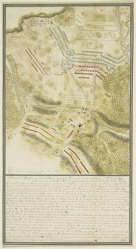
Map of the Battle of Fontenoy, 1745 (Fontenoy, Walloon Region, Belgium) 50°34'03"N 03°28'24"E c.1745
RCIN 729094
By 1745, Cumberland was commanding the Allied army. He needed to regain the key town of Tournai, south-west of Brussels, which had been besieged by the French. The two forces met at Fontenoy, near Tournai, on 11 May 1745. The French had chosen a ridge of high land which forced Cumberland’s men to advance up a slope under heavy fire. Cumberland had to retreat, but won praise for his bravery as did Sir John Ligonier, a senior Hanoverian soldier, a bust of whom is displayed nearby.
From the King’s Military Map Collection; probably made for William Augustus, Duke of Cumberland
Cat. 50
