-
1 of 253523 objects
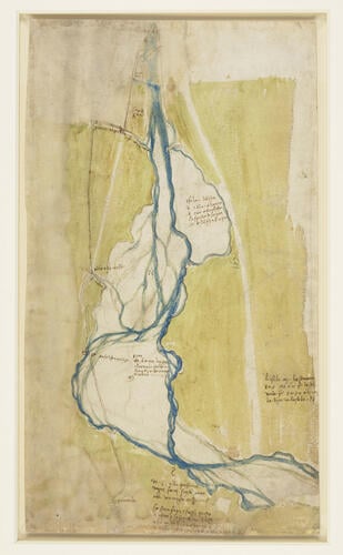
A map of the Arno west of Florence 1504
Pen and ink, blue and green wash | 42.2 x 24.2 cm (sheet of paper) | RCIN 912678
-
A drawing of a map covering about 2.5 miles (4 km) of the Arno, with north to the left; coloured with washes and complete with notes (written in the conventional direction) identifying mills, the sizes of sandbanks and so on; drawn to a scale of about 1:10,000. RCIN 912677 and 912678 are maps covering the stretch from the Porta al Prato, the western gate of Florence, to the village of Peretola. Melzi's number 167.
Leonardo was a respected engineer and mapmaker – among other projects, he worked for a spell as military architect to Cesare Borgia, Marshal of the Papal Troops; he drew up plans to drain the malarial Pontine Marshes south of Rome; and he planned a great canal to bypass the river Arno from the sea to Florence. In the summer of 1504 Leonardo surveyed stretches of the Arno to the east and west of Florence, probably as a commission from the city government. The Arno is a mountain torrent, low in the summer but prone to flooding in the spring and autumn, and the banks of the river required regular maintenance to keep its mills viable.
Text adapted from Leonardo da Vinci: A life in drawing, London, 2018Provenance
Bequeathed to Francesco Melzi; from whose heirs purchased by Pompeo Leoni, c.1582-90; Thomas Howard, 14th Earl of Arundel, by 1630; probably acquired by Charles II; Royal Collection by 1690
-
Creator(s)
Acquirer(s)
-
Medium and techniques
Pen and ink, blue and green wash
Measurements
42.2 x 24.2 cm (sheet of paper)
Markings
watermark: Eagle in circle [-]

