-
1 of 253523 objects
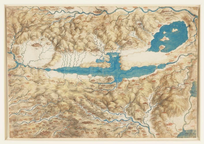
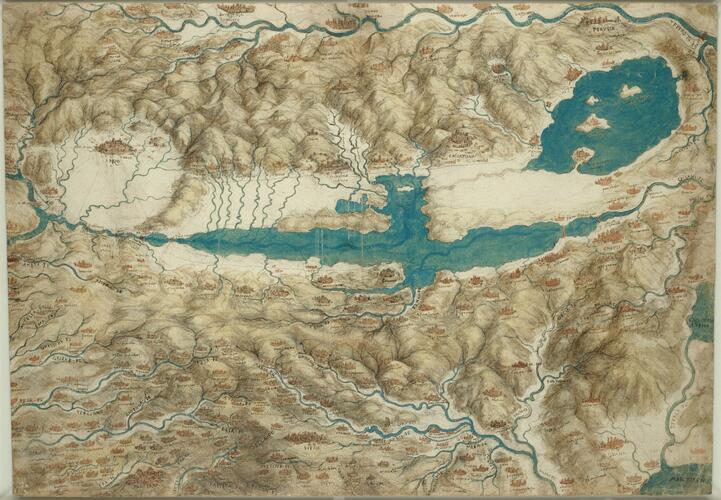
A map of southern Tuscany c.1503-6
Black chalk, pen and ink, brown wash and blue bodycolour | 33.8 x 48.8 cm (sheet of paper) | RCIN 912278
-
A carefully finished map of southern Tuscany, centring on the long marshy lake that once occupied the Valdichiana. North is to the left, the Tiber runs along the top edge, and the southern bend of the Arno is at centre left; Arezzo is at upper left, Perugia at upper right, and Siena lower centre.
The purpose of the sheet is not evident, though the high level of finish, and the fact that the labels are written in the conventional direction (rather than Leonardo's usual mirror writing) indicate that it must have been made for someone else to see. Leonardo was employed by the Florentine government on several projects in civil and military engineering, and given that the Valdichiana is the focus of the map, it is probable that it was made in connection with a plan to drain the malarial marsh of the Valdichiana, a project which engaged the Florentines for several centuries, and a field in which Leonardo clearly attained some reputation.
The Valdichiana was also part of Leonardo's scheme to canalise the Arno (see 912279, 912685): by damming the southern outflow and using sluices to control the northern outflow (as described by Leonardo in Codex Atlanticus fol. 46v-a), it would be possible to regularise the level of the Arno, which was subject to marked seasonal variations.
Alternatively, Solmi in 1912 suggested that the map may have been made while Leonardo was in the service of Cesare Borgia in 1502-3, and specifically in connection with the revolt of Arezzo against Cesare in June 1502. Solmi took as his evidence the lists of distances on 912682 and in Leonardo's MS L, and the fact that a series of lines seem to radiate out from Arezzo here; but in truth the city is accorded no more prominence than its size would warrant, and the lakes and waterways are plainly the focus of attention here, rather than the roadways that would be of more use to a military operation.
See also RCIN 912682 for a bird's-eye view of the Valdichiana with distances indicated, probably preparatory for this sheet; and 912277 for a geographical map of a larger area.Provenance
Bequeathed to Francesco Melzi; from whose heirs purchased by Pompeo Leoni, c.1582-90; Thomas Howard, 14th Earl of Arundel, by 1630; probably acquired by Charles II; Royal Collection by 1690
-
Creator(s)
Acquirer(s)
-
Medium and techniques
Black chalk, pen and ink, brown wash and blue bodycolour
Measurements
33.8 x 48.8 cm (sheet of paper)


