-
1 of 253523 objects
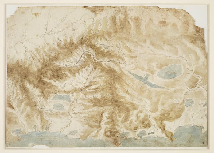
A map of the rivers and mountains of central Italy c.1502-4
Black chalk, pen and ink, brown and blue wash | 31.7 x 44.9 cm (sheet of paper) | RCIN 912277

Leonardo da Vinci (1452-1519)
A map of the rivers and mountains of central Italy c.1502-4

Leonardo da Vinci (1452-1519)
A map of the rivers and mountains of central Italy c.1502-4


-
A coloured map of northern Italy. With north to the left, this map shows 170 miles (275 km) of the western coast of Italy from La Spezia to Civitavecchia, with the promontories of Piombino and Monte Argentario heavily shaded. The focus of attention is the Arno valley; the lakes of Valdichiana and Trasimeno (see 912278) and the upper Tiber occupy the right side of the sheet, and the Po is roughly sketched at upper left, though it flows in the wrong direction. All the rivers, lakes and cities are named, and many villages in the upper Arno valley. In the sea below left, the note 'La toscana e finjta dal mare / e dalla magra dal tevere e da / lalpe'. Melzi's number 175.
Leonardo’s drawing is based on a map of c.1470, now in the Vatican but then in the ducal library in Urbino, a city he visited during his surveying work for Cesare Borgia in 1502 (see S. Kish, 'Leonardo da Vinci: The Mapmaker', in Imago et mensura mundi, Rome 1985, I, pp. 89-98). Leonardo transformed his model with the use of relief shading, and added much detail in the upper Arno and its principal tributary the Sieve, where mere streams and villages are included.
A sheet in the Codex Atlanticus (Milan, Biblioteca Ambrosiana; fol. 334r) is a tracing by Leonardo of the outlines of the map, with only a few localities between the Romagna and Tuscany named, which has been taken as evidence that Leonardo made the map when touring that region in the service of Cesare Borgia. But the map was relevant to several of Leonardo’s projects in military and civil engineering in the years around 1502–4, and more generally reflects his long interest in the habits of rivers. It is likely that he made it for his own reference as a summary of all his available knowledge on the topography of central Italy.Provenance
Bequeathed to Francesco Melzi; from whose heirs purchased by Pompeo Leoni, c.1582-90; Thomas Howard, 14th Earl of Arundel, by 1630; probably acquired by Charles II; Royal Collection by 1690
-
Creator(s)
Acquirer(s)
-
Medium and techniques
Black chalk, pen and ink, brown and blue wash
Measurements
31.7 x 44.9 cm (sheet of paper)