


-
1 of 253523 objects
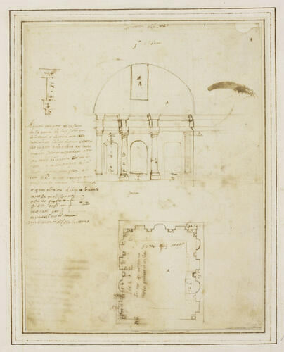
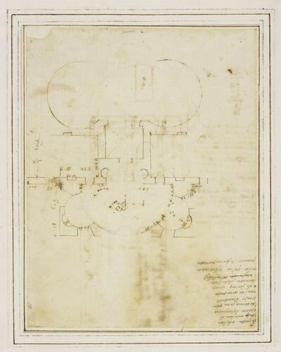
Recto: Tomb over two miles from the Porta di S. Giovanni: plan and details. Verso: unidentified building, possibly baths, via Latina: plan 1568-70
Pen and brown ink over black chalk. Watermark: Hills (Hills 22) [cut] | 26.0 x 20.2 cm (sheet of paper) | RCIN 910369
Anonymous Portuguese (active 1568–70)
Recto: Tomb over two miles from the Porta di S. Giovanni: plan and details. Verso: unidentified building, possibly baths, via Latina: plan 1568-70
-
Recto: elevation of the interior of a tomb outside the Porta di San Giovanni with ground plan below and annotations and measurements. Verso: ground plan of unidentified building with annotations and measurements. Twenty-five folios by an unidentified Portuguese hand are found in the first part of the album Architectura Civile (RCIN 910354-60, 910364-76, 910378-80, 910427, 910440). They comprise one of the larger groups of drawings in the extant Paper Museum. Apart from one sheet of details of the Pantheon (RCIN 910376), and another of portable antiquities from Tivoli (RCIN 910427), all the drawings are taken from ancient Roman buildings, predominantly tombs, in the Campagna east and south-east of Rome.
Three groups of drawings are keyed to form series: the first, in which this sheet falls, distinguishes monuments by a single letter, running discontinuously from A to S (RCIN 910354, 910357, 910360, 910364, 910367-70, 910372-3). For further discussion of the series and the wider group of twenty-five folios, see dal Pozzo A.IX, pp. 312-317.
Recto: A perspectival elevation of the interior of the end wall of the tomb, with three niches (1.85m high) framed by Tuscan columns (shafts 2.45m) beneath a projecting entablature. The upper profile of the wall, and the tall rectangular window at the top marked A, suggest the chamber had a barrel vault. The horizontals of the entablature extend to the right and left as if it was intended to ‘fold out’ the side walls. To the left of the elevation are details of the entablature and of the column base and plinth. Below is the plan of the tomb, showing that the pattern of alternately semi-circular and rectangular niches continued with four down each of the side walls. The reference in front of the left-hand wall to four arches on the floor below implies that the tomb also had a basement level, presumably revealed by the collapse of the floor above. Since no door or other details are recorded on the fourth side, the front wall of the tomb may have been largely missing, though it would be the usual place to expect the other two square windows mentioned in the annotation.
From the information provided in the notes beside the drawings, the tomb stood over two miles outside the Porta di San Giovanni, towards a famous stretch of the aqueducts known as Le Forme (visible on the map of the Campagna published by Eufrosino della Volpaia in 1547; T. Ashby, La Campagna romana al tempo di Paolo III: mappa della Campagna romana del 1547 di Eufrosino della Volpaia, 1914) and to the left of the ruins called Centocelle. The tomb’s location corresponds to the second cluster of tombs described by Ashby in his account of the via Latina, noting that the farthest tomb, the seventh in line, was ‘a mere mass of debris’ (Ashby ‘Classical topography in the Roman Campagna III’, Papers of the British School at Rome IV, 1907, p. 71f.). Ashby identified the adjacent, sixth, tomb with a different set of drawings (RCIN 910364). However, his description of the sixth tomb as all of brick and barrel-vaulted fits the present tomb rather better than that in 910364 which, according to its accompanying notes, was constructed of alternating courses of brick and tufa blocks (opus vittatum) and was cross-vaulted.
The drawings seem to be the unique testimony to the tomb and, given the accuracy of other drawings by this draughtsman, can probably be relied upon. The absence of details of the exterior may indicate that the tomb was partly buried at the time. As the notes and numbering make clear, this is the first tomb of the group drawn by this draughtsman. As well as linking the plan and elevation, the letter A also refers to succeeding lettered drawings down to N, which form one sequence. The draughtsman goes to such lengths to provide clear topographical information and explanation that it seems likely that he was drawing them at first hand, unless he was copying the annotations as well as the drawings – though the fact that several annotations are crossed out goes against this possibility.
The sheet has small holes in each corner, perhaps indicating that it was pinned down for tracing. The same watermark is found on 910380.
*
Verso: This measured plan shows a complex of rooms laid out on the same axis: an indeterminate space flanked by two three-quarter circles, possibly vaulted, communicates by way of a smaller square, cross-vaulted room, with a large semicircular chamber (diameter over 7.6m), off which open two smaller three-quarter circular vestibules, each containing a semicircular niche between two angled doorways. The combination of shapes and the dimensions suggest part of an ancient bath building or perhaps an elaborate dining pavilion of the second or third century AD.
The note at bottom right places it near the stretch of aqueducts known as Le Forme, where the tomb on the recto was also drawn. The road to Frascati would be the via Tuscolana but the other place name mentioned, seemingly ‘Ferrara fu(o)ri pala’, is not otherwise known. The ruins called Le Vignacce, which belong to a villa of the Hadrianic period, lie in the vicinity and include some similar sequences of spaces (T. Ashby 1907, p. 74f.; T. Ashby and G. Lugli, ‘La villa dei Flavi Cristiani “ad duas lauros”’, Atti della Pontificia Accademia Romana di Archeologia XI, 1928, pp. 183–92).
Numbering: Recto:[top centre] primeiro (‘first’) [top right corner] 1 Verso: [top edge centre] secundo. 2
Key Lettering: Recto: [on elevation and plan of tomb] A
Annotations: Recto: measurements in palmi; [top edge, centre] al forme (‘at Le Forme’); [top field, centre] p (or) ta s. Joáne (‘Porta S. Giovanni’); [left of elevation] A queste tempieto es ta fora/ de la porta de san Juoane/ de letrano e de terra cota tutto /co soi colone del medesimo coperti/ de stuquo e dordem toscano/ quanto sepo comp(r)endere esta/ lontano di la porta doi milia/ o piu a canto sempre de li co(n)/duti a ma manqua a li/ 100 celi a tre frenestre quelo que/ si uede come la fenestra A/ o qua drato da banda leuante/ come se ta ali forme/ esta no queste te(m)/pieti cosi numerati par li/ conuersi modi [xxxx] principiando dil piu lontano (‘This temple-tomb is outside the Porta di S. Giovanni and all of brick with its columns of the same covered with stucco and of the Tuscan order, as far as one can tell. And it stands 2 miles or more distant from the gate still on the side of the aqueducts on the left hand of Centocelle. It has three windows, that which one sees in the window [marked] A. or square on the east side, as if towards Le Forme, these temple-tombs are numbered in reverse order beginning from the farthest’); [below elevation] prima (‘first’); [on plan] sono 4 3 arque (‘there are three arches’); [sideways] son 4 arque/ nelo pianta disoto (‘there are four arches in the floor below’).
Verso: measurements in palmi; [bottom right corner, inverted] Aqueste edifi tio/ esta A anco fora di/
la porta de san juane/ de terra cota esta/ apreso li condute / molto aruinato/ a ali formi apreso/ ferrara furipala/ a casa de esta sulastrada qui va a frascatta/ quanto se po coprender (‘This building is also outside the Porta S. Giovanni, of brick near the aqueducts, very ruined, at Le Forme near ‘Ferrara furipala’ in the house of And it lies on the road which goes to Frascati as far as one can tell’)
Text adapted from Ian Campbell, The Paper Museum of Cassiano dal Pozzo: A Catalogue Raisonné. A.IX: Ancient Roman Topography, London 2004, cat.102-3.Provenance
From the ‘Paper Museum’ of Cassiano dal Pozzo (1588-1657) and his brother Carlo Antonio dal Pozzo (1606-1689), mounted in the album Architectura Civile, fol. 16; dal Pozzo ‘type A’ mount. Sold by Carlo Antonio's grandson to Clement XI Albani, 1703; acquired by Cardinal Alessandro Albani in 1714, from whom purchased by George III in 1762.
-
Creator(s)
(collector) -
Medium and techniques
Pen and brown ink over black chalk. Watermark: Hills (Hills 22) [cut]
Measurements
26.0 x 20.2 cm (sheet of paper)
Markings
watermark: Hills 22 (cut)
Category
Object type(s)
Other number(s)
RL 10369


