-
1 of 253523 objects
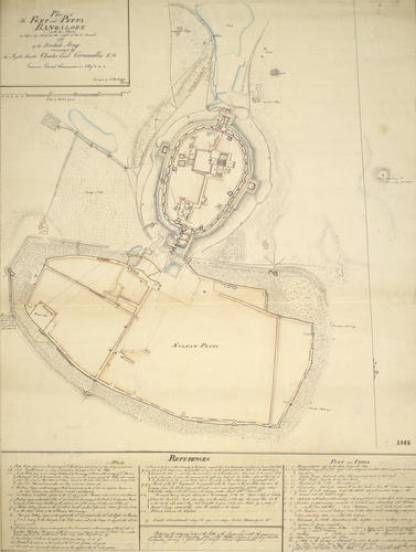
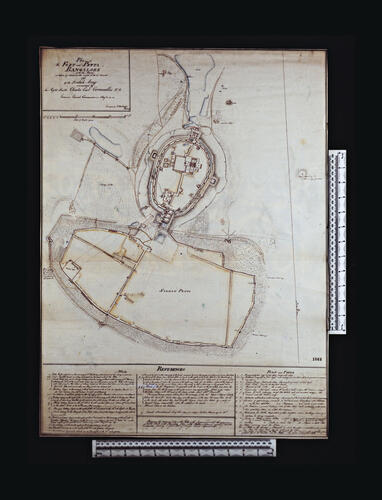
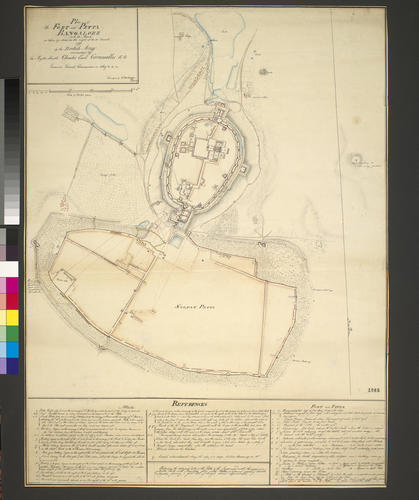
Map of the siege of Bangalore, 1791 (Bengalore, Karnātaka, India) 12°58'19"N 77°35'37"E c.1791
Pencil, pen, ink and watercolour on paper | 66.8 x 49.7 cm (image) | RCIN 735001

Colin Mackenzie (active 1783-d. 1821)
Map of the siege of Bangalore, 1791 (Bengalore, Karn?taka, India) 12?58'19"N 77?35'37"E c.1791

Colin Mackenzie (active 1783-d. 1821)
Map of the siege of Bangalore, 1791 (Bengalore, Karnātaka, India) 12°58'19"N 77°35'37"E c.1791

Colin Mackenzie (active 1783-d. 1821)
Map of the siege of Bangalore, 1791 (Bengalore, Karn?taka, India) 12?58'19"N 77?35'37"E c.1791


-
A map of the attacks by the British army, commanded by Charles, First Marquess Cornwallis (1738-1805), Governor-General of India, on the fort and petta of Bangalore, 21 March 1791. Third Anglo-Mysore War (1789-92). Oriented with south to top (cardinal points).
The town and fortifications of Bangalore were besieged by the British East India Company from 5 February to 21 March 1791. This plan shows the oval-shaped fortress with the pettah, or fortified town, to the north. The perimeter of the fort measured one mile, and the 26 towers along the ramparts, which commanded the encircling wide ditch, are plainly shown.
Lieutenant Colin Mackenzie, the author of this plan, took part in the action, crossing the ditch with scaling ladders and entered the fort through a breach in the walls.
Additional text: [bottom, across bottom of map in rectangular panel, a descriptive key, a-i, k-y and 1-23, to the gates, batteries, parallels, march of the 76th regiment, and physical features, such as the construction materials of the fort and petta:] REFERENCES.
For further reading, see:
E.W.C. Sandes, The military engineer in India, 2 vols, London, 1933; republished 1997, pp.163-5.
Scale: 1:16,000 approx. Scale bar: Scale of British yards [113 mm =] 2000.
Condition: one fold line; surface dirt on both sides; brown discolouration to both sides.
Creator detail: [bottom right of title panel:] Surveyed by C. Mackenzie Lt & Sub Eng.r.Provenance
From the collection of military and naval maps and prints formed by George III (1738-1820)
-
Creator(s)
Acquirer(s)
-
Medium and techniques
Pencil, pen, ink and watercolour on paper
Measurements
66.8 x 49.7 cm (image)
54.3 x 49.0 cm (neatline)
67.2 x 49.9 cm (whole object)
Markings
watermark: Fleur-de-lys in crowned shield, the scrolled letter W below; countermark: JWHATMAN
annotation: Old heading: Bangalore 21 March 1791. Other annotations: (Recto) [bottom left, in References, black pencil:] one [?] 1025 yd. (Verso) none.
Category
Alternative title(s)
Plan of / The FORT and PETTA / BANGALORE / (with the Attacks) / as taken by storm on the night of the 21t March / 1791 / by the British Army / commanded by / The Right Honble Charles Earl Cornwallis K.G. / Governor General, Commander in Chief &c. &c. &c.
Bangalore A drawn Plan of the Fort and Petta Bangalore with the attacks as taken by storm on the night of the 21.st March 1791, by the British Army commanded by Earl Cornwallis: by Lieut. C. Mackenzie Eng.r.