-
1 of 253523 objects
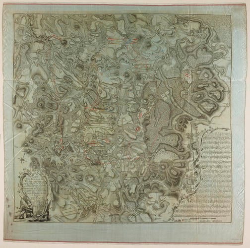
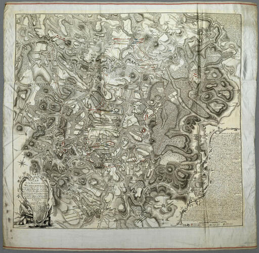
Map of the Battle of Wilhelmsthal, 1762 (Wilhelmsthal, Hesse, Germany) 51°24'00"N 09°25'00"E 1763
Engraving and etching; printed from two copperplates on two pieces of silk subsequently sewn together; hand coloured | 86.0 x 88.3 cm (image) | RCIN 733057

Jakob van der Schley (1715-79)
Map of the Battle of Wilhelmsthal, 1762 (Wilhelmsthal, Hesse, Germany) 51°24'00"N 09°25'00"E 1763

Jakob van der Schley (1715-79)
Map of the Battle of Wilhelmsthal, 1762 (Wilhelmsthal, Hesse, Germany) 51°24'00"N 09°25'00"E 1763
Jakob van der Schley (1715-79)
Map of the Battle of Wilhelmsthal, 1762 (Wilhelmsthal, Hesse, Germany) 51°24'00"N 09°25'00"E 1763


-
A map, printed on silk, of the Battle of Wilhelmsthal, fought on 24 June 1762 between the Allied army (British, Prussian, Hessian and Brunswickian troops) under the command of Field Marshal Duke Ferdinand of Brunswick, Prince of Brunswick-Lüneburg (1721-92), and the French, commanded by Charles de Rohan, prince de Soubise (1715-87), resulting in an Allied victory. Seven Years War (1756-63). Oriented with north-north-west to top (compass rose).
Additional text: [bottom right, in rococo cartouche, an extensive account of the movements and actions of the troops in the battle, and key A-I, K-P, R-T, V-Z, a:] RELATION de la BATAILLE.
Dedication: [bottom left, below title, in title cartouche:] Dedié / à S.A. Serme Mon Seig.r le Prince / Ferdinand Duc de Brunswic et de Lunebourg. / par son tres humble et tres / soumis Serviteur F.W. de / Bawr, Colonel et Chef d’un / Regiment d’Husars de / Sa Majeste Prussienne.
Scale: 1:46,400 approx. Scale bar: Echelle de 6000 Pas communes, ou une heure de Chemin [105 mm =].
Condition: three fold lines; slightly creased, otherwise in pristine condition.
Creator detail: [below title, in title cartouche, dedication:] F.W. Bawr.
Creator detail: [bottom centre, outside border:] Grave Sous la Direction de J.v.Schley, et Publié à La Haye aux Depens de PIERRE GOSSE junior & DANIEL PINET, MDCCLXIII.Provenance
Probably from the collection of military and naval maps and prints formed by Prince William Augustus, Duke of Cumberland (1721-65), third son of George II; subsequently acquired by George III (1738-1820)
-
Creator(s)
(publisher)(publisher)Acquirer(s)
-
Medium and techniques
Engraving and etching; printed from two copperplates on two pieces of silk subsequently sewn together; hand coloured
Measurements
86.0 x 88.3 cm (image)
84.5 x 87.7 cm (neatline)
92.7 x 96.5 cm (whole object)
Markings
watermark: N/A
annotation: Old heading: Wilhelmsthal. Other annotations: none.
dummy sheet (K Mil): Title [ink:] Plan de la Bataille de Wilhelmsthal; donné le 24 Juin 1762, entre l'Armée / de sa Majesté Britannique, commandée par le Prince Ferdinand, Duc de / Brunswic et de Lunebourg; et l'Armée de France, aux ordres des / Marechaux, Comte d'Etrées, et Prince de Soubise: par le Colonel F.W. de Bawr / 1763. / Another Copy of Ditto on Silk ... A Roll ... [black pencil:] 5 Table 2.d / [old heading, red ink:] Battle of Wilhelmsthal 24 June 1762.
Watermark: fleur-de-lys in crowned shield, the scrolled letter W below.
Size: 47.5 x 33.3 cm (sheet). [no RCIN; not on fiche]Category
Object type(s)
Alternative title(s)
PLAN / de la BATAILLE de / WILHELMSTHAL / donnée le 24 Juin 1762. entre l’Armée / de Sa Majeste Brittannique Commandée / par S.A. Ser.me Mon Seigneur LE PRINCE / FERDINAND DUC de BRUNSWIC et / de LUNEBOURG, et l’Armée de France / aux Ordres de Messieurs les MARECHAUX / COMTE de ‘ETRÉES et PRINCE / de SOUBISE.
Wilhelmsthal Plan de la Bataille de Wilhelmsthal donnée le 24 Juin 1762, entre l’Armée de Sa Majesté Britannique commandée par le Prince Ferdinand Duc de Brunswic et de Lunebourg, et l’Armée de France aux ordres des Marechaux Comte d’Estrées et Prince de Soubise: par le Colonel F.W. Bawr, 1763. Another copy of D.o on Silk.