-
1 of 253523 objects
Map of the Battle of Culloden, 1746 (Culloden Moor, Highland Region, Scotland, UK) 57°28'00"N 04°05'00"W dated 23 April 1746
Pencil, pen, ink and watercolour on paper; in cream card mount | 34.2 x 42.7 cm (image) | RCIN 730028

Thomas Sandby (1721-98)
Map of the Battle of Culloden, 1746 (Culloden Moor, Highland Region, Scotland, UK) 57°28'00"N 04°05'00"W dated 23 April 1746
Thomas Sandby (1721-98)
Map of the Battle of Culloden, 1746 (Culloden Moor, Highland Region, Scotland, UK) 57°28'00"N 04°05'00"W dated 23 April 1746

-
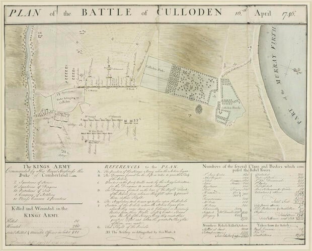
A map of the Battle of Culloden fought on 16 April 1746 between the King's army, commanded by William Augustus, Duke of Cumberland (1721-65) and the Jacobite army, under Charles Edward Stuart (1720-88) resulting in a royal victory. Jacobite Rebellion (1745-6). Oriented with south-west to top (cardinal points).
This map shows the same details as Dugal Campbell's map (RCINs 730026, 730027). This polished plan is a fair drawing showing the opposing armies drawn up in line of battle with the flanking movement of the Dragoons and the lines of flight of the rebels. When this map is placed beside Thomas Sandby's sketch of the Battle of Culloden (RCIN 914722; Oppé (Sandby) 151) it is clear that the details of the view do not match those of the plan. The line of sight of the view is along the centre of the opposing lines of battle, which would be due south. However, the Moray Firth (annotated ‘Murray Firth’) is in the left middle distance, or to the south-east whereas it actually lay to the north-east. A prominent building in the middle distance (south-south-east in the view) appears to be Castle Stuart, which actually lies not far from the shores of the Moray Firth, again, to the north-east.The plan gives no indication of the positions which the Duke of Cumberland took up during the battle, but the sketched view places him prominently in the front line, in between Pulteney’s and the Royals. The view does not show Cumberland's artillery, and appears to depict the moment when the Rebel's right flank attacked Cumberland's left wing, and before the Dragoons were ordered to circle to the left, pass through the detached parts of Culloden Parks to the south, and attack the rebels to the rear of their right flank. The view also shows more walls within the Parks than are shown on this plan (or any of the other plans). Sandby has placed a highlander on a knoll in the foreground; this artificial device for producing a higher viewpoint would have been necessary to achieve an uninterrupted view down the line of battle; such a view would have been impossible on the ground because the battlefield was not level, being lower at the north and south ends than in the middle. Thomas Sandby's view of the battlefield of Culloden was presumabely the same one which hung in ‘His Royal Highness' Bed Chamber’ (Inventory of Household Furniture of His Late Royal Highness The Duke of Cumberland at Windsor Great Lodge.)
Additional text: [below map, three columns of text, left to right:] The KINGS Army / commanded by His Royal Highness the / Duke of Cumberland [followed by an enumeration of the troops and the numbers killed and wounded in the King's army]; REFERENCES to the PLAN [explanation of the letters A-G]; Numbers of the several Clans and Bodies which com- / posed the Rebel Forces.
Scale: no scale stated. 1:13,000 approx.
Condition: three fold lines; worn and torn along folds; trimmed to edge of image; surface dirt; pencil copying squares, numbered across the top, are visible across the face of the map. These were examined 9/12/2010 and it is the opinion that the pencil squaring is on top of the map detail. The ‘squares’ are approximately 33 x 28 mm; holes along lines of topographical features indicate pricking through for copying purposes; slight creasing; tears left, and along fold lines have been repaired; laid down on card in a Royal Library mount.
Creator detail: [bottom left, below text, inside border:] T. Sandby delin.t April 23d 1746 at Inverness.Provenance
From the collection of military and naval maps and prints formed by Prince William Augustus, Duke of Cumberland (1721-65), third son of George II; subsequently acquired by George III (1738-1820)
-
Creator(s)
(draughtsman)Acquirer(s)
-
Medium and techniques
Pencil, pen, ink and watercolour on paper; in cream card mount
Measurements
34.2 x 42.7 cm (image)
19.2 x 42.4 cm (neatline)
Markings
watermark: Strasburg lily in crowned shield suspending the letter W
annotation: Old heading: none visible. Other annotations: (Recto) none. (Verso) none visible because of card backing.
Category
Subject(s)
Other number(s)
RL 17177Alternative title(s)
PLAN of the BATTLE of CULLODEN 16.th April 1746.
Culloden A drawn Plan of the Battle of Culloden, 16.th April 1746; by T. Sandby, 1746.