-
1 of 253523 objects
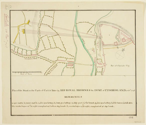
Plan of the siege of Carlisle, 1745 (Carlisle, Cumbria, England, UK) 54°53'42"N 02°56'17"W 1745 or later
Pencil, pen, ink and watercolour on paper | Scale: 1:2,000 approx. (scale) | RCIN 729160
-
A plan of the successful siege of Carlisle, 21-30 December 1745, by the British army, commanded by William Augustus, Duke of Cumberland (1721-65). Jacobite Rebellion (1745-6). Oriented with north-west to top (cardinal points).
The Jacobites, commanded by Prince Charles Edward Stuart (1720-88), had reached Carlisle on 9 November 1745 and Lieutenant-Colonel James Durand, commanding the castle, surrendered on the 14th. A garrison of 350 Rebel soldiers was left to defend the castle. The Duke of Cumberland reached Carlisle on 21 December and after delays in the supply of artillery, caused by adverse weather and bad roads, the castle was surrendered on the 30th.
This plan shows the locations of the two batteries constructed by Cumberland's troops and the lines of fire from them to the castle. Whitehaven and Rose Castle Roads are named, as well as the Calder River and Mill Race. The structures coloured in carmine would have been masonry buildings.
Additional text: [bottom, below title, in title panel, a key, a-i, k-l, to the various parts of the castle and the batteries and attack works:] REFERENCES.
Condition: no fold lines; acid from the ink lines of the bottom and top borders has eaten through the paper. Verso: induced discolouration.Provenance
Probably from the collection of military and naval maps and prints formed by Prince William Augustus, Duke of Cumberland (1721-65), third son of George II; subsequently acquired by George III (1738-1820)
-
Creator(s)
(cartographer)Acquirer(s)
-
Medium and techniques
Pencil, pen, ink and watercolour on paper
Measurements
Scale: 1:2,000 approx. (scale)
27.1 x 32.2 cm (image)
16.7 x 31.3 cm (neatline)
31.2 x 36.4 cm (sheet) (whole object)
Markings
watermark: Coat of arms: a lion rampant holding a bunch of arrows in one paw and a hat perched on top of a staff in the other, standing on a rectangular base on which is inscribed ‘VRYHEYT’, all within a circular surround described by two inner and two outer lines within which is, at the top, a decorative device, and the words: PROPATRIA EIUSQUE LIBERTARE within the circle; the whole beneath a crown; countermark: the letters GR, crown above [not in Heawood or Churchill]
annotation: Old heading: Carlisle 30 Dec.r 1745. Other annotations: (Recto) [along left edge, black pencil, erased: old heading]. (Verso) [bottom left, black pencil:] VIII/6 [very neat: in Schultz's or Mason's hand?]; [top left, black pencil:] XI/12-b.
Category
Alternative title(s)
Plan of the Attack on the Castle of Carlisle Taken by, HIS ROYAL HIGHNES [sic] the DUKE of CUMBERLAND. 30 de.br 1745.
Carlisle. A drawn Plan of the attack on the Castle of Carlisle, taken by the Duke of Cumberland, 30 Dec.r 1745.
