-
1 of 253523 objects
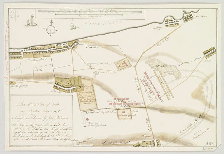
Map of the Battle of Prestonpans, 1745 (Prestonpans, East Lothian, Scotland, UK) 55°57'33"N 02°58'49"E c.1746
Pencil, pen, ink and watercolour on paper; copying squares, about 1 cm square, drawn in pencil across face of map | Scale: 1:21,700 approx. (scale) | RCIN 729154

John Elphinstone (1706-53)
Map of the Battle of Prestonpans, 1745 (Prestonpans, East Lothian, Scotland, UK) 55°57'33"N 02°58'49"E c.1746

-
A map of the Battle of Prestonpans, fought on 21 September 1746 between the Jacobite army, commanded by Prince Charles Edward Stuart (1720-88), and the British army, commanded by General Sir John Cope (1690-1760), resulting in a Jacobite victory. Jacobite Rebellion (1745-6). Oriented with north-north-west to top (cardinal points).
The map shows the position of the British army on the night of 20/21 September, the deep ditch at the front of the camp, the march route of the Rebels, from Tranent, through the southern end of a morass to a point just east of a ‘Waggon Way’ and their order of battle, the locations of the soldiers' (presumably British) graves, and the park of Preston House where many of the British soldiers were slaughtered by the Rebels.
The Battle of Prestonpans was the first engagement between the Jacobite, or Rebel army led by Prince Charles Edward Stuart, and the British army led by Sir John Cope.
Additional text: [bottom left, below author statement, in title panel:] N b: Some of the Rebells had conseald them / selves in the Ditch in Our front notwithstand / ing Our advanced guard, the Morrass in / the Plan is Seldom Impassible [sic] but in Winter / after great Rains and scarse then to highlanders.
For further reading, see:
S. Brumwell, ‘Cope, Sir John (1690–1760)’, Oxford Dictionary of National Biography, 2004.
Condition: no fold lines; right corner diagonally cut off. Verso: induced discolouration.Provenance
Probably from the collection of military and naval maps and prints formed by Prince William Augustus, Duke of Cumberland (1721-65), third son of George II; subsequently acquired by George III (1738-1820)
-
Creator(s)
(surveyor)(draughtsman)Acquirer(s)
-
Medium and techniques
Pencil, pen, ink and watercolour on paper; copying squares, about 1 cm square, drawn in pencil across face of map
Measurements
Scale: 1:21,700 approx. (scale)
20.4 x 30.6 cm (image)
20.3 x 30.4 cm (neatline)
21.6 x 31.9 cm (sheet) (whole object)
Markings
watermark: Fleur-de-lys in shield, crown above, a ‘4’ suspending the letters LVG below
annotation: Old heading: Battle of Preston Pans 21 Sept.r 1745. Other annotations: (Recto) none. (Verso) [centre, red pencil:] 4.
Category
Alternative title(s)
Plan of the Field of Battle / near Preston Septr 21 1746 [i.e. 1745]
Preston Pans. A drawn Plan of the Field of Battle near Preston Pans, 21.st of Sept.r 1745: by John Elphinstone Eng.r