-
1 of 253523 objects
Map of the Battle of Preston, 1715 (Preston, Lancashire, England, UK) 53°46'00"N 02°43'00"W 1715 or later
Etching and engraving; printed on paper; hand-coloured | Scale: not stated. Not to scale. (scale) | RCIN 726093

Abel Boyer (1667?-1729)
Map of the Battle of Preston, 1715 (Preston, Lancashire, England, UK) 53°46'00"N 02°43'00"W 1715 or later
Abel Boyer (1667?-1729)
Map of the Battle of Preston, 1715 (Preston, Lancashire, England, UK) 53°46'00"N 02°43'00"W 1715 or later

-
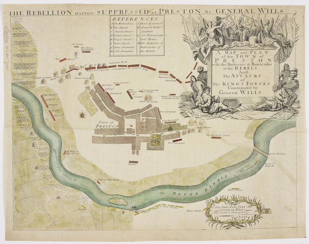
A map of the Battle of Preston, fought between 9 and 14 November 1715 between British forces, commanded by Major-General Charles (later, Sir Charles) Wills (1666-1741) and Lieutenant-General George Carpenter (1657-1732), and the Jacobite Rebels, commanded by Brigadier William Mackintosh, Laird of Borlum (1658-1743), William Maxwell, 5th Earl of Nithsdale (1676-1744), James Radclyffe, 3rd Earl of Derwentwater (1689-1716), and the Jacobite General, Thomas Forster (1683-1738), resulting in victory for the government forces. Jacobite Rising (1715). Oriented with north to top.
Abel Boyer, the publisher of this map, was a French Hugenot journalist and military. Boyer was born at Castres (upper Languedoc), and came to England in 1689, having apparently seen service in the Dutch army and having been educated, amongst other subjects, in mathematics and fortification. He had in 1695 published A geographical and Historical Description of those parts of Europe which are the Seat of War and in 1699 published the Royal Dictionary which made his name. This was followed by several works including, in 1701, The Draughts of the most Remarkable Fortified Towns of Europe. In 1704 he seems to have become an intelligence agent for the Secretary of State for the northern department, Robert Harley. Boyer became a firm supporter of the Hanoverian succession and this was reflected in many of his publications, including this map of the Battle of Preston.
This map bears a resemblance in layout and design to the roughly-executed manuscript map at RCIN 726092. The references to streets and buildings is almost identical, albeit in English rather than French. Although there are some differences in detail, it is a possibility that this printed map may have been based on the manuscript version.
The houses were razed by order of Wills who had hoped that the spreading flames would reach the positions of the Jacobites who had barricaded themselves in the main streets, shown to good effect in this map. The battle was won only after Wills's troops were reinforced by six squadrons under the command of General Carpenter, shown here to the top right, or north-east, of the map.
A later version of this map, apparently engraved after a map by Charles St.Clare in 1818, after an original plan of 1715, was published in Lancashire Illustrated, in 1836. This version lacks the decorated cartouche which is left as a plain tablet.
Dedication: [bottom right, in oval cartouche framed by olive branches:] TO THE IMMORTAL FAME OF / GENERAL WILLS / This PLATE is dedicated by, / his humble Serv.t / A. BOYER.
Additional text: [across top of map:] THE REBELLION HAPPILY SUPPRESSED AT PRESTON BY GENERAL WILLS. [Top centre, a key, A-I, K-M, to the names of streets and buildings in the town and the batteries and barricades of the rebels:] REFERENCES.
For further reading, see:
G.C. Gibbs, ‘Boyer, Abel (1667?–1729)’, Oxford Dictionary of National Biography, 2004; online edn, Jan 2008.
S. Handley, ‘Wills, Sir Charles (bap.1666, d. 1741)’, Oxford Dictionary of National Biography, 2004.
H.M. Stephens, ‘Carpenter, George, first Baron Carpenter of Killaghy (1657–1732)’, Oxford Dictionary of National Biography, 2004; online edn, May 2008.
E. Lord, The Stuarts' Secret Army: English Jacobites 1689-1752, Harlow, 2004, p. 83.
Condition: six fold lines; unevenly folded, surface dirt on outside fold panel; creased. Verso: a large amount of surface dirt.Provenance
Probably from the collection of military and naval maps and prints formed by Prince William Augustus, Duke of Cumberland (1721-65), third son of George II; subsequently acquired by George III (1738-1820)
-
Creator(s)
(publisher)(dedicatee)Acquirer(s)
-
Medium and techniques
Etching and engraving; printed on paper; hand-coloured
Measurements
Scale: not stated. Not to scale. (scale)
35.6 x 45.9 cm (image)
37.3 x 48.5 cm (platemark; bottom edge indistinct) (platemark)
34.6 x 45.9 cm (neatline)
37.8 x 48.8 cm (sheet) (whole object)
Markings
watermark: None
annotation: Old heading: Preston 13 Nov.r 1715. Other annotations: (Recto) [bottom right, black pencil:] Nov 13 1715. (Verso) [top left, red pencil:] 6/[?3]; top left, black pencil: VII/3.
Category
Object type(s)
Alternative title(s)
A MAP and PLAN / of the TOWN of / PRESTON / with the Batteries & Barricades / of the REBELS, / And / The ATTACKS / of / The KINGS FORCES / Commanded by / General WILLS.
Preston Plan of the Town of Preston with the Batteries and Barricades of the Rebels and the Attacks of the King's Forces commanded by General Wills, 13 Nov.r 1715: by A. Boyer.