-
1 of 253523 objects
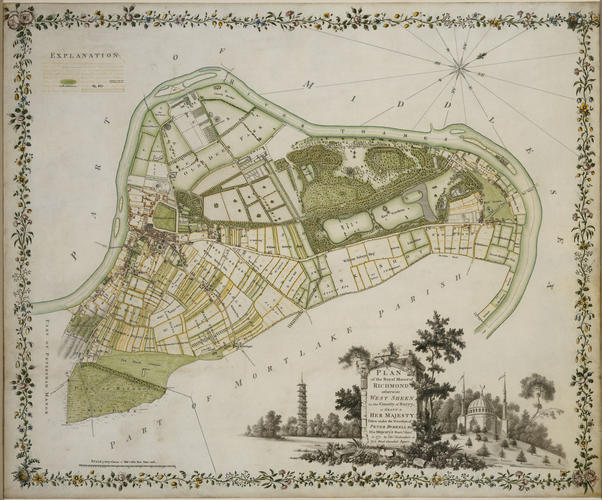
Plan of the Royal Manor of Richmond dated 1771
Pen and ink and grey wash and watercolour on vellum | 56.3 x 65.6 cm (frame) (frame, external) | RCIN 503056
-
This fine and decorative plan records the adjacent estates of Richmond and Kew, to the west of London, in the year before the death of the King's mother, the Dowager Princess of Wales. Thereafter the two estates were jointly occupied by the King; however, they were only physically united in 1802.
The plan is oriented with north at top right; the town of Richmond (with its ferry crossing over the River Thames) is shown at centre left. The plan was made at the time of the King's proposals to build a new palace at Richmond, and to set it within a new landscape garden. The central strip of land within the curve of the river represents the remains of the village of West Sheen, purchased by George III in the 1760s as part of this scheme. Lancelot ( 'Capability') Brown was engaged to redesign the landscape at the same time. His work involved the destruction of the park buildings and formal planting that had been introduced to Queen Caroline's pleasure grounds at Richmond by William Kent and Charles Bridgeman in the 1730s. According to Arthur Young, writing at around the time that this plan was made, 'Richmond Gardens have been lately altered: the terrass and the grounds about it are now converted into waving lawn that hangs to the river in a most beautiful manner'.
Within the area of the Old Deer Park at top left on this plan (just above the Lodge) is the King's Observatory, built by Chambers (as a gift from the Dowager Princess of Wales to her son) to enable the King to view the transit of Venus in 1769. The Observatory was erected close to the site of the temporary pavilion designed by Chambers to entertain the King's brother-in-law, Christian VII of Denmark, who had visited Richmond in September 1768. To the right of Richmond Lodge are Queen Charlotte's pleasure grounds and the clearing containing her 'New Menagerie' where exotic birds and animals (among them kangaroos sent from Australia) were kept. Soon after the date of this plan, the menagerie building was converted into a thatched tea house (Queen Charlotte's Cottage). Immediately below this is the broad band representing the Kew estate with (from left to right) the Pagoda - in a circular clearing - at the left end of the two lawns, the lake, a further area of lawn and the White House with adjacent buildings. The Dutch House is indicated between the White House and the river. At far right is Kew Green and Kew Bridge. The title plaque includes views of two of Chambers's pleasure buildings on the Kew estate - the Pagoda and the Mosque. The King's farms, where some of his Merino sheep were kept, occupied part of the area left white along the bottom of the plan.
A number of versions of Richardson's plan are known. The King's detailed plan of the main upper central area remains in its original ornately tooled red leather case in the British Library. All of these plans were 'Taken under the Direction of Peter Burrell Esq. His Majesty's Surveyor General' in 1771, to record 'the Royal Manor of Richmond . . . in grant to Her Majesty'. The manor of Richmond had been formally granted to Queen Charlotte in October 1770.
Catalogue entry adapted from George III & Queen Charlotte: Patronage, Collecting and Court Taste, London, 2004Provenance
Made for George III
-
Creator(s)
(surveyor)(draughtsman)Acquirer(s)
-
Medium and techniques
Pen and ink and grey wash and watercolour on vellum
Measurements
56.3 x 65.6 cm (frame) (frame, external)
50.1 x 60.4 cm (whole object)
Category
Alternative title(s)
Plan of the Royal Manor of Richmond, otherwise West Sheen, in the County of Surrey, in Grant to Her Majesty.
