
-
1 of 253523 objects
Atlas Russicus 1745
55.0 x 36.1 x 3.0 cm (book measurement (conservation)) | RCIN 1046761

Académie Imperiale des Sciences, St Petersburg
Atlas Russicus mappa una generali et undeviginti specialibus vastissimum Imperium Russicum . . . / cura et opera Academiae Imperialis Scientiarum Petropolitanae = Atlas Russien : contenant une carte générale et dixneuf cartes pariculières . . 1745

Académie Imperiale des Sciences, St Petersburg
Atlas Russicus mappa una generali et undeviginti specialibus vastissimum Imperium Russicum . . . / cura et opera Academiae Imperialis Scientiarum Petropolitanae = Atlas Russien : contenant une carte générale et dixneuf cartes pariculières . . 1745

Académie Imperiale des Sciences, St Petersburg
Atlas Russicus mappa una generali et undeviginti specialibus vastissimum Imperium Russicum . . . / cura et opera Academiae Imperialis Scientiarum Petropolitanae = Atlas Russien : contenant une carte générale et dixneuf cartes pariculières . . 1745
-
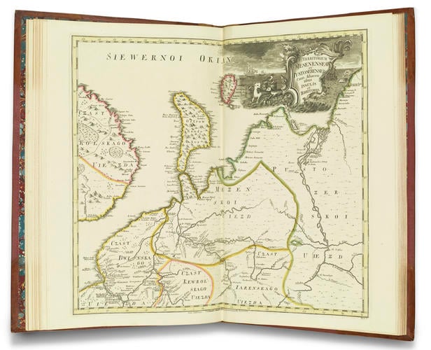
Atlas Russicus is the first full atlas of Russia, based on the first national survey of the whole country at a uniform scale for both European (13 maps) and Asiatic Russia (6 maps). It was based on work by Ivan Kirilovich Kirilov (1695–1737), first secretary of the Russian Senate, and Joseph Nicolas de l’Isle (1688–1768), French astronomer and cartographer to Louis XV (1710–74), who had been invited to Russia by Peter the Great to contribute to his grand mapping scheme. The Emperor’s urge to Europeanise Russia also included reaping the benefits of being properly mapped according to European standards. From c.1700 he started creating home-grown geodesists (as he called surveyors/cartographers), founding the Moscow Mathematical and Navigational School in 1701, where students aged 12–17 (up to 20 after 1710), studied arithmetic, geometry and trigonometry. In 1715 he set up a geodesic institute within the St Petersburg Naval Academy, to which he invited skilled foreigners to train a new generation of Russians. He soon had his own geodesists ready to be packed off into the field to survey Russian territory and help compile a complete atlas of the Russian Empire. Part of Kirilov’s atlas was published in 1734, but he died before he could publish the rest. The new atlas was eventually published in 1745, based on de l’Isle’s survey, and maps produced by Peter the Great’s geodesists. The atlas usually contains 20 maps, ending with a map of the whole Russian empire (missing from this copy).
The map illustrated here shows the area of St Petersburg and the White Sea region, Russia’s route to Europe before she established reliable warm-water routes, and Europe’s first trade route to Russia in the sixteenth century. The White Sea was the route first used by English sailors in 1553, under the command of Richard Chancellor (d.1556), who landed in the area of Archangelsk (Archangel), before making contact with Moscow and journeying south to negotiate trading rights for the Muscovy Company. The White Sea had the disadvantage of freezing every winter, and the (slightly) warmer route through the Gulf of Finland (via St Petersburg) only became possible in the early eighteenth century, after Peter the Great’s conquest of lands on the southern shores of the Gulf of Finland and the foundation of St Petersburg, which gave Russia better control over this more southern sea route.
Provenance
Possibly acquired during the regin of Queen Victoria
-
Creator(s)
(corporate author)Acquirer(s)
-
Measurements
55.0 x 36.1 x 3.0 cm (book measurement (conservation))
Alternative title(s)
Atlas Russicus mappa una generali et undeviginti specialibus vastissimum Imperium Russicum ... / cura et opera Academiae Imperialis Scientiarum Petropolitanae = Atlas Russien : contenant une carte générale et dixneuf cartes pariculières ...